File:PIA17946-MarsCuriosityRover-PlannedRoute-20140218.jpg

Original file (3,300 × 2,550 pixels, file size: 1.63 MB, MIME type: image/jpeg)
Summary
| Description |
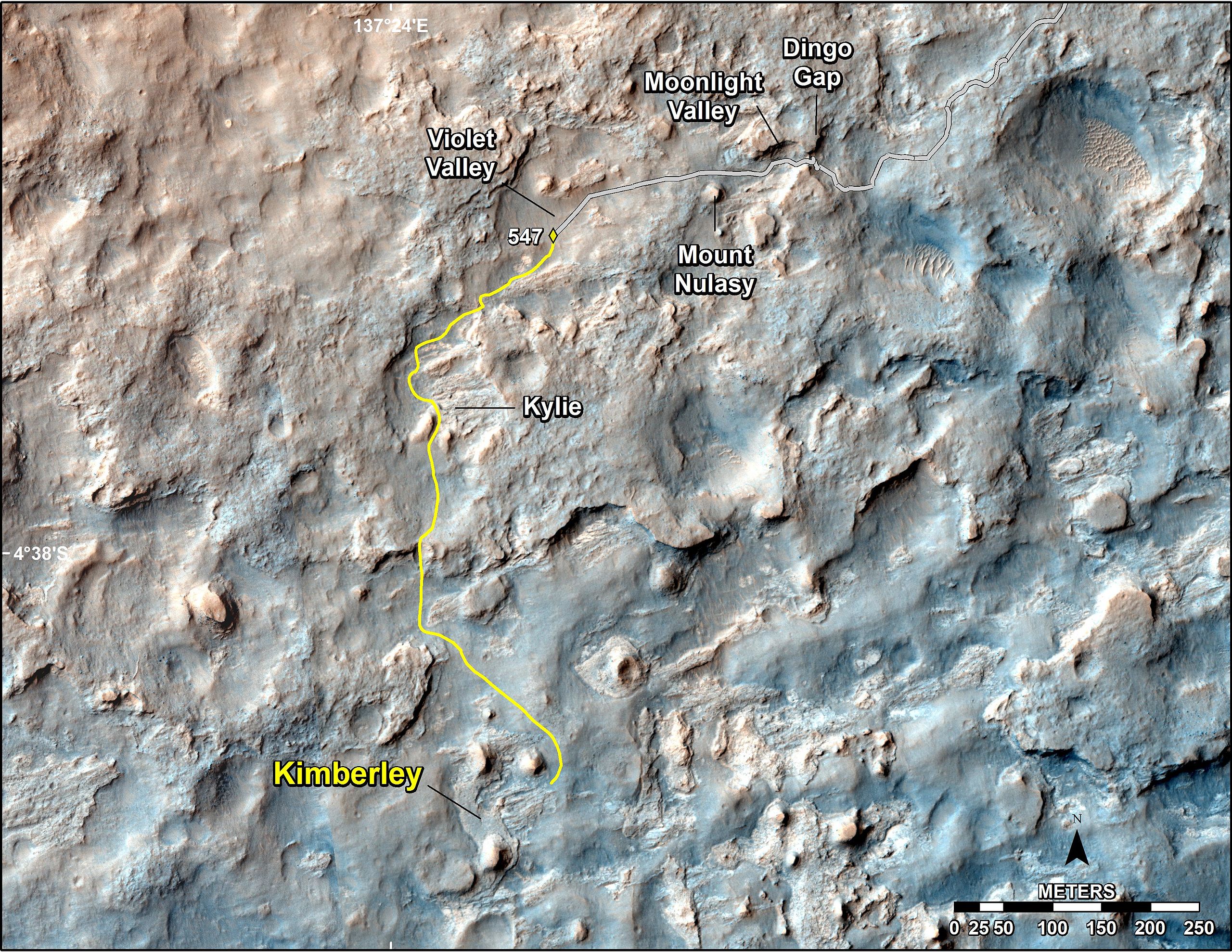
English: PIA17946: Map of Recent and Planned Driving by Curiosity as of Feb. 18, 2014
http://photojournal.jpl.nasa.gov/catalog/PIA17946 This map shows the route driven and route planned for NASA's Curiosity Mars rover from before reaching "Dingo Gap" -- in upper right -- to the mission's next science waypoint, "Kimberley" (formerly referred to as "KMS-9") -- in lower left. The point labeled 547 on the route is where Curiosity finished a drive of 319 feet (100.3 meters) on the 547th Martian day, or sol, of the rover's mission on Mars (Feb. 18, 2014). The map's line to that point is the path actually traveled; the yellow line past that is a planned route. Curiosity entered the area covered by this map in late 2013 and passed through Dingo Gap on Sol 535 (Feb. 9, 2014). To see the traverse through Sol 546 (Feb. 17, 2014) in larger context to include earlier parts of the mission, see http://mars.jpl.nasa.gov/msl/multimedia/images/?ImageID=6007. The base image for this map is a combination of images from the High Resolution Imaging Science Experiment (HiRISE) camera on NASA's Mars Reconnaissance Orbiter. North is up. NASA's Jet Propulsion Laboratory, a division of the California Institute of Technology, Pasadena, manages the Mars Science Laboratory Project for NASA's Science Mission Directorate, Washington. JPL designed and built the project's Curiosity rover and Navcam. More information about Curiosity is online at http://www.nasa.gov/msl and http://mars.jpl.nasa.gov/msl/.Polski: Polska wersja opisu zdjęcia na podstawie artykułu Mapa przejazdu łazika Curiosity w dniu 18 lutego 2014 r..
Mapa ta, wskazuje maszrutę zaplanowaną i zrealizowaną przez należący do NASA łazik Curiosity, od "Dingo Gap" -- prawy górny róg -- do następnego naukowego punktu kontrolnego "Kimberley" (uprzednio nazywanego "KMS-9") -- lewy dolny róg. Punkt oznaczony na trasie liczbą 547 wskazuje miejsce w którym Curiosity zakończył kolejny etap wynoszący 100.3 metrów w 547 marsjańskim dniu, lub sol, podczas realizacji misji łazika na Marsie, na Ziemi był wtedy 18 luty 2014. Linia do tego punktu wskazuje trasę przejechaną; żółta linia wskazuje trasę zaplanowaną. Curiosity wszedł na obszar objęty tą mapą pod koniec 2013 i przeszedł przez Dingo Gap w Sol 535 (9 lutego 2014). Bazowy obraz wykorzystany na tej fotografii pochodzi z instrumentu HiRISE umieszczonym na należącym do NASA orbiterze Mars Reconnaissance Orbiter. Północ jest na górze. Ciemne podłoże na przyszłej trasie łazika w dolnych skarpach Mount Sharp jest materiałem nawianym przez wiatr. Należący do NASA Jet Propulsion Laboratory (JPL), będący wydziałem California Institute of Technology w Pasadenie, kieruje projektem Mars Science Laboratory dla należącego do NASA Science Mission Directorate w Waszyngtonie. JPL zaprojektował i zbudował łazik Curiosity i kamery navcam. |
| Date | |
| Source | http://photojournal.jpl.nasa.gov/jpeg/PIA17946.jpg |
| Author | NASA/JPL-Caltech/Univ. of Arizona |
Licensing
| This file is in the public domain in the United States because it was solely created by NASA. NASA copyright policy states that "NASA material is not protected by copyright unless noted". (See Template:PD-USGov, NASA copyright policy page or JPL Image Use Policy.) | ||
 |
Warnings:
|
File history
Click on a date/time to view the file as it appeared at that time.
| Date/Time | Thumbnail | Dimensions | User | Comment | |
|---|---|---|---|---|---|
| current | 01:33, 20 February 2014 | | 3,300 × 2,550 (1.63 MB) | wikimediacommons>Drbogdan | User created page with UploadWizard |
File usage
The following page uses this file:
Global file usage
The following other wikis use this file:
- Usage on miraheze.org

